


The world’s oceans provide a carbon sink that has so far kept humanity from feeling the full impact of escalating atmospheric CO2. According to analyses of our best current data sets, the seas absorb and store one out of every four carbon molecules spewed into the atmosphere by humanity, making the ocean a vital hedge against catastrophic climate change.
But as the planet heats up, forecasts do not agree on how much carbon the oceans will continue to store. Increasingly intense ocean winds are stirring up carbon-rich waters from the deep seas, adding more carbon back into the atmosphere than expected. While many computer models suggest the world’s vast oceans will keep up their carbon uptake, other observation-based data indicate there is greater variability in the ocean carbon sink — which could lead to faster accumulation of CO2 in the atmosphere.
The trouble with current global estimates of the total carbon stored in the oceans is that they are mostly based on evidence gathered by a relatively small number of ships and moorings. These methods can only sample the seas in limited places and times. But the oceans are immense, and researchers could be missing major releases of carbon back into the atmosphere, especially in remote regions.
Increased oceanic emissions, if not accurately accounted for over time, could adversely impact global carbon budgets and climate models too, throwing off climate predictions that help inform policy.
Scientists are proactively responding to this problem. To get near-real-time carbon measurements from across the world, they’re steadily building out an international fleet of high-tech robot floats. The idea is that integrating reams of real-time data from these thousands of ocean-drifting robots into climate models will greatly improve modeling accuracy, and even help better monitor land-based carbon emissions, providing more accurate national tallies useful in verifying international climate agreement targets.
 The global carbon budget 2010-19, showing that Earth’s “bank account” is seriously out of balance due to human inputs. A balanced carbon budget would see less CO2 emissions going into the atmosphere due to human activities with more storage by land and ocean carbon sinks. As the planet heats up, there are uncertainties regarding how much carbon is being stored and released from ocean sinks, and therefore, questions about the levels of atmospheric carbon dioxide in the future. Credit: Infographic reproduced from the Global Carbon Atlas (www.globalcarbonatlas.org).
“Without knowing where those [carbon] molecules are going, there is no accountability — not for carbon emissions by country, not for carbon dioxide removal schemes, and not for the health of the planet,” says Joellen Russell, oceanographer and climate scientist at the University of Arizona, in Tucson.
Carbon budget out of balance?Figuring out Earth’s oceanic carbon budget is like balancing a checkbook; it’s a matter of accounting precisely for how much goes in and how much comes out. The ocean pulls carbon dioxide out of the atmosphere in two ways: Zooplankton absorb CO2 for photosynthesis, or the CO2 follows the chemical gradient and dissolves into the oceans because there’s more in the atmosphere and less in the sea.
Once the surface waters take up the atmospheric carbon, the CO2 then moves deep into the ocean. In this way, a significant amount of human-generated CO2 in the atmosphere is stored deep beneath the waves, and hundreds of years could pass before it is outgassed again.
But when ocean winds intensify in places where there is a carbon-rich water subsurface, that excess stirring can move more of that carbon-rich deep water back to the surface, releasing greenhouse gases back into the atmosphere. That process is exactly what is being seen now in the Southern Ocean around Antarctica as climate change escalates.
 The Antarctic Circumpolar Current is the only ocean current that circumnavigates the planet, linking the Atlantic, Indian and Pacific basins. “It’s profoundly the deepest, wildest, most incredible reservoir of carbon on Earth,” says Joellen Russell, who has spent months on research vessels sampling seawater in the Southern Ocean. “When the winds blow harder, more of that carbon comes up. That s a worry.” Image courtesy of the European Union, Copernicus Marine Environment Monitoring Service.
This increased real-time oceanic stirring has introduced significant uncertainty regarding the flow of anthropogenic carbon back into the atmosphere, explains Russell.
Most current global carbon models assume that the ocean carbon sink is stable and will remain so, even though the climate is getting warmer, Russell says. These models are based on the idea that warmer ocean waters will stratify — that there would be less mixing. “That would be true if the only thing that were happening was just the heat,” she says. In the last decades, winds have picked up markedly especially off Antarctica. And simulations show that those high winds are churning deeper in the ocean, leading to more carbon outgassing.
“But I want real data, not simulations,” Russell states.
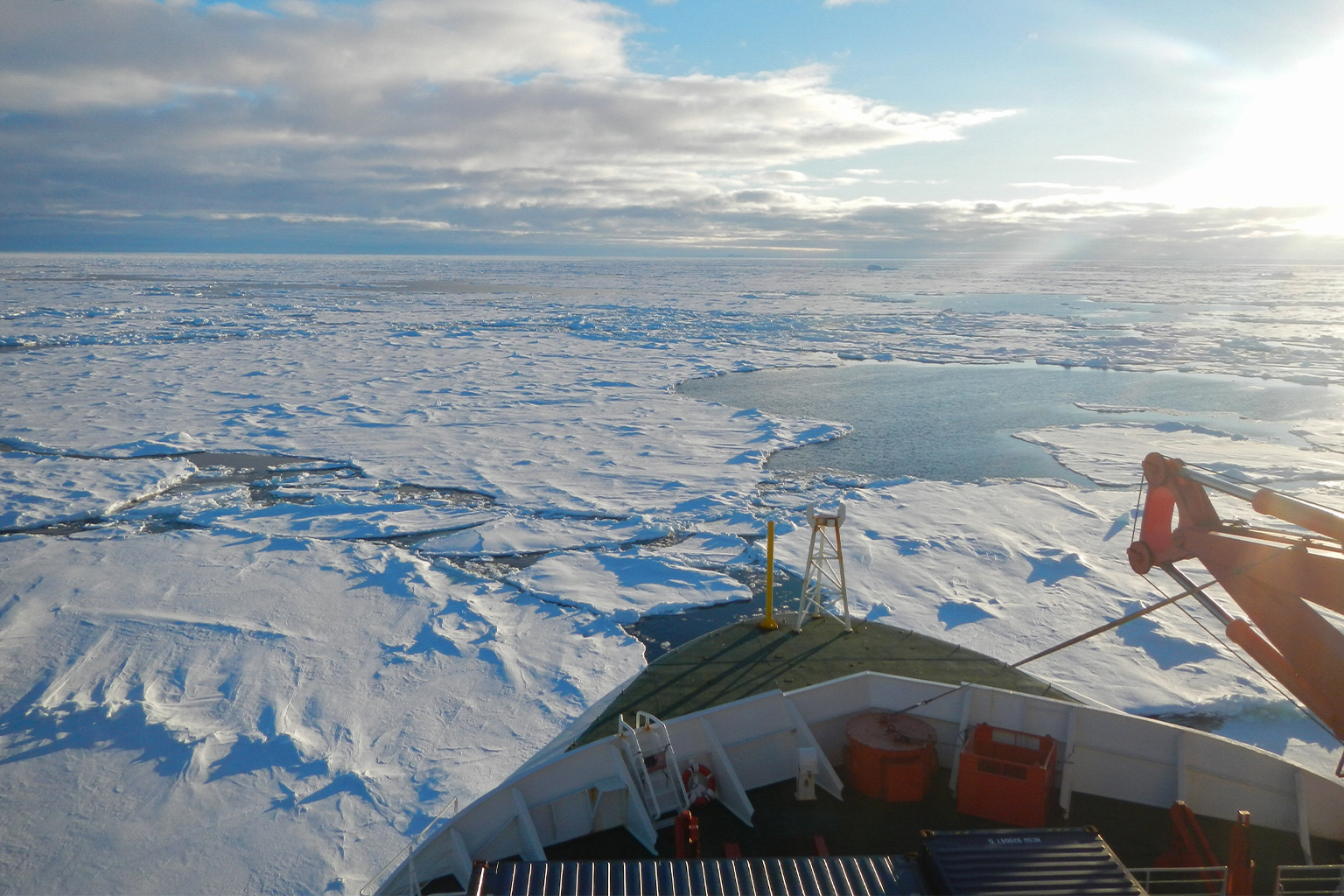
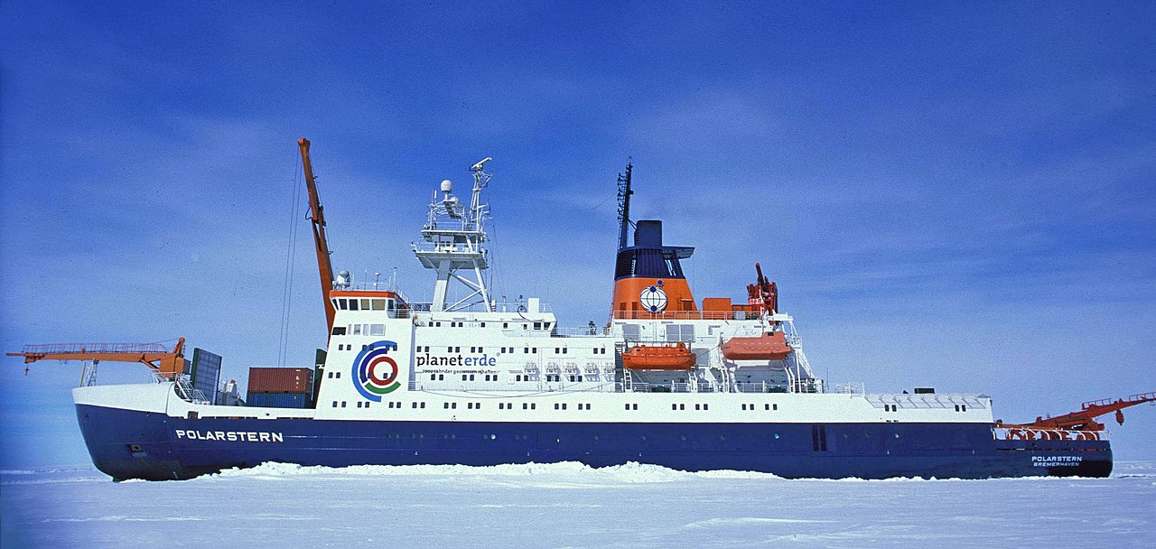 The RV Polarstern, a German research icebreaker of the Alfred Wegener Institute for Polar and Marine Research (AWI). While data collected from such vessels is accurate, robot floats can collect significantly more data in remote and inhospitable locations, including during the Antarctic winter. Image by Hannes Grobe, Alfred Wegener Institute, via Wikimedia Commons (CC BY-SA 2.5).
Measuring ocean carbon
The RV Polarstern, a German research icebreaker of the Alfred Wegener Institute for Polar and Marine Research (AWI). While data collected from such vessels is accurate, robot floats can collect significantly more data in remote and inhospitable locations, including during the Antarctic winter. Image by Hannes Grobe, Alfred Wegener Institute, via Wikimedia Commons (CC BY-SA 2.5).
Measuring ocean carbon
Historically, ocean carbon has been estimated using seawater samples taken by research vessels or at moorings. These measurements are considered highly accurate, but the data collected from all the world’s oceans is sparse at best. And samples from the inhospitable Southern Ocean around Antarctica — where almost half of the global oceanic carbon sink occurs — are even more scant.
Satellite observations of ocean color have also been used as a proxy for CO2 measurements. But gathering that type of data requires cloud-free days, which can be rare in polar regions, and that type of imaging can only typically be done down to a depth of 40 meters (130 feet).
The collection of real-time data could dramatically improve our understanding of carbon movement in and out of the sea, and improve our predictions. So getting far-flung, numerous samples from many remote places matters, says Russell.
In fact, it matters a lot: An array of models run for the most recent Intergovernmental Panel on Climate Change (IPCC) report found that, depending on which model was used, the amount of carbon estimated to be going into the Southern Ocean varies by at least 50 parts per million. “And these are the best models in the world,” says Russell. “So I m concerned.”
That’s a disturbing amount of variance between models, considering there is less than a 50-ppm difference between current anthropogenic CO2 levels in the atmosphere (about 418 ppm) and the threshold of a potential climate disaster at 450 ppm of carbon dioxide.
 Getting ocean samples the “traditional” way: From on board a research vessel. “My students and I go out to sea for months at a time,” says Joellen Russell. “We lower a big array of water bottles over the side, and fill them at different depths. Then we run those samples on shipboard instruments. You can get about five of those profiles every two days. So for about 100 grand you get five profiles.” Image by Hannah Zanowski/SOCCOM via Flickr (CC BY 2.0).
Thankfully, say researchers, the degree of uncertainty in ocean measurements is steadily being narrowed. Traditional ship-based and mooring data collection is now being complemented by satellites, gliders, drones and other autonomous monitoring platforms — even elephant seals. All help to more accurately measure the carbon dioxide fluxes going across the sea surface-air interface.
But even this improved monitoring often is plagued by lengthy data reporting gaps of weeks, months, or even decades, and doesn’t cover some of Earth’s remotest regions.
“We re [still] undersampling,” warns Katja Fennel, an oceanography professor at Dalhousie University in Nova Scotia, Canada. “This has been a really pronounced problem for understanding ocean biogeochemistry.”
If ocean models are to be rigorously tested against observations, then more samples and data points are needed to assure that current ocean carbon budget models aren’t wrong. “Until we get better observations to more fully test the models against those [actual measurements], we’re really stuck,” says Fennel.
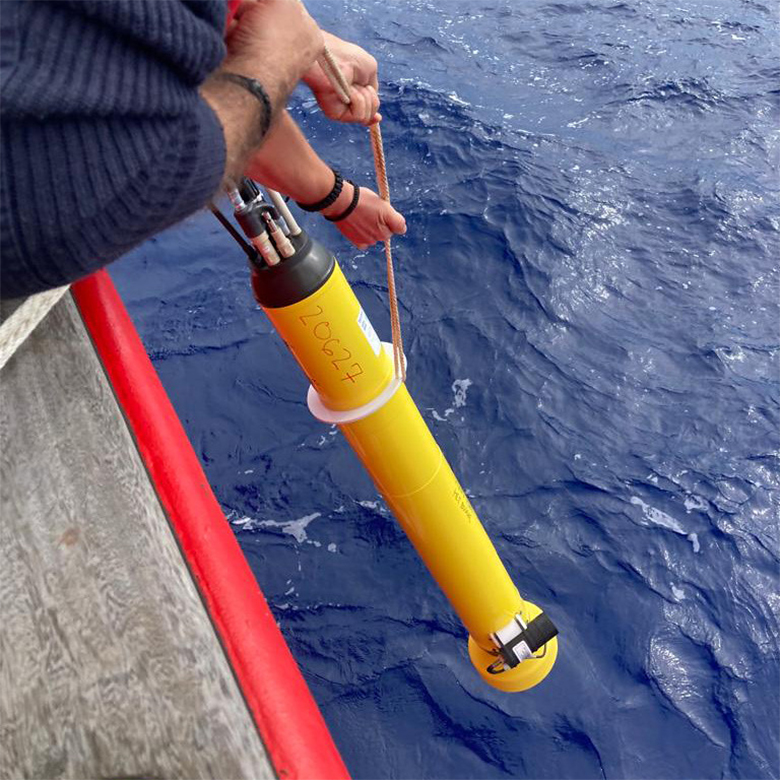 Deploying a SOCCOM robot float. “It’s a revolution in oceanography: We re looking at not just the surface flux, but the changing [ocean] inventories,“ says Joellen Russell. “There’s been nothing like it, basically ever. This is humanity s best, first, closest look at how our ocean moves and changes in real time.” Image by Isa Rosso/SOCCOM via Flickr (CC BY 2.0).
Robots to the rescue
Deploying a SOCCOM robot float. “It’s a revolution in oceanography: We re looking at not just the surface flux, but the changing [ocean] inventories,“ says Joellen Russell. “There’s been nothing like it, basically ever. This is humanity s best, first, closest look at how our ocean moves and changes in real time.” Image by Isa Rosso/SOCCOM via Flickr (CC BY 2.0).
Robots to the rescue
Most ocean models estimate carbon flux across sea surfaces, averaging the amount of carbon dioxide being absorbed or outgassed over time. But in the real world, imagine what happens when storm patterns change, says Russell. Storm size, location and distribution all alter flux patterns. As a result, scientists say they may be missing what’s truly going on with carbon flux.
Robot floats offer a way to look at that ocean carbon inventory in more detail, and especially at how it is changing in real time. In 2014, the Southern Ocean Carbon and Climate Observations and Modeling project (SOCCOM), began deploying the first of 200 floats outfitted with temperature, depth and salinity sensors.
These floats built on the “core” global Argo array, an international program of nearly 4,000 robot floats that has been collecting temperature and salinity data across the world’s oceans for more than 20 years. This expanding network is especially important in places like the Southern Ocean where SOCCOM floats can still collect data amid fierce winds, 30-m (100-ft) waves and drifting icebergs. Samples from those floats have detected seasonal and locational shifts in the carbon budget that hadn’t been captured in samples from ships only sailing in the Southern Hemisphere summer.
“I want to know where all of the [carbon] molecules are — in the atmosphere and in the ocean — where we re basically doing an equivalent of [widespread] statistical sampling and assimilating that data into a dynamic model so that we can track flows from box to box all over the world [in real time], in the atmosphere and in the ocean, and then attribute the amount of emissions from the surface in each country,” Russell explained during a virtual meeting for science writers. “We need to be able to verify [these national carbon emissions] the way we would verify a nuclear treaty.”
 Anatomy of a SOCCUM robot float. Image courtesy of SOCCOM.
But there’s even more exciting data to come. The SOCCOM program has been extended to 2024 with floats loaded with more biogeochemical sensors. And an international global ocean biogeochemical float program, GO-BGC Argo , will endeavor to put 1,000 additional profiling floats into the world’s oceans. With the first GO-BGC float deployed in March 2021, these new biogeochemical outposts have the capacity to carry six sensors to measure oxygen, pH, nitrate, sunlight (downwelling irradiance), chlorophyll, and suspended particles (including macroalgae and bacteria).
By combining the pH observations with estimates of total alkalinity, scientists can get more accurate measures of the sea surface partial pressure of CO2 (pCO2) and how it changes throughout the year. With these pCO2 records, researchers can assess how much anthropogenic carbon dioxide the oceans are absorbing. (When oceanic pCO2 growth rates are slower than the atmospheric growth rates, the ocean carbon sink increases.)
Importantly, the floats take profiles every 10 days from the surface down to a depth of 2,000 m (6,600 ft), and then feed the data back by satellite. Each float has at least a five-year life span and the data is freely available in near real time.
So far, about 62 of these new, advanced sensor floats have been deployed. The U.S. is slated to provide a total of 500 floats, half of the international array, over a five-year span with funding from the National Science Foundation and the National Oceanic and Atmospheric Administration (NOAA), with more than a dozen other countries adding robot floats to the armada, too.
 A thousand robotic floats outfitted with up to six biogeochemical sensors each will generate real-time data that can help scientists more accurately assess ocean carbon. These data streams will also be included in the Surface Ocean CO2 Atlas (SOCAT), an international effort to deliver a uniform, quality-controlled surface ocean CO2 database. Image courtesy of GO-BGC.
Robot floats “can observe seasonal and inter-annual change in carbon cycling, oxygen minimum zones, nutrient flux, acidification, phytoplankton … there really is no limit,” says Ken Johnson, GO-BGC s project director and an ocean chemist at the Monterey Bay Aquarium Research Institute in California. “It just depends on the imagination of scientists.”
Most floats deployed to date don t yet carry the full suite of sensors; that’s partly due to money. Johnson describes the oxygen sensor as “reasonably affordable,” but it alone comes at a cost of about $25,000. Then there’s the commercially made nitrate sensor costing $30,000, and a pH sensor at around $10,000; it all adds up. “I tell people every time I launch a float it s like rolling a Tesla Model S off the back of the ship,” Johnson says.
Though floats may sound expensive, in 10 days each one can get as many as 250 profiles, compared to five from on board a research ship. And each float serves as part of a vital ocean monitoring system.
Johnson, who developed the original nitrate sensors for the floats, sees today’s robots as extremely important to gauging ocean health. “If you were ill and go off to the hospital, they don t immediately throw you in the MRI. They take your pulse, your temperature, blood pressure: the vital signs. We’re kind of at that level where we re taking the vital signs of the ocean.” And knowing those vital signs can point policymakers toward viable climate solutions.
While even 1,000 new robot floats still won’t be sufficient to fill all the data gaps, their performance will far exceed the data-gathering capacity of ships that don’t go where the robots can. “The real trick now is to be able to convince people we can show change over years to decades as the carbon budget changes,” Johnson says.
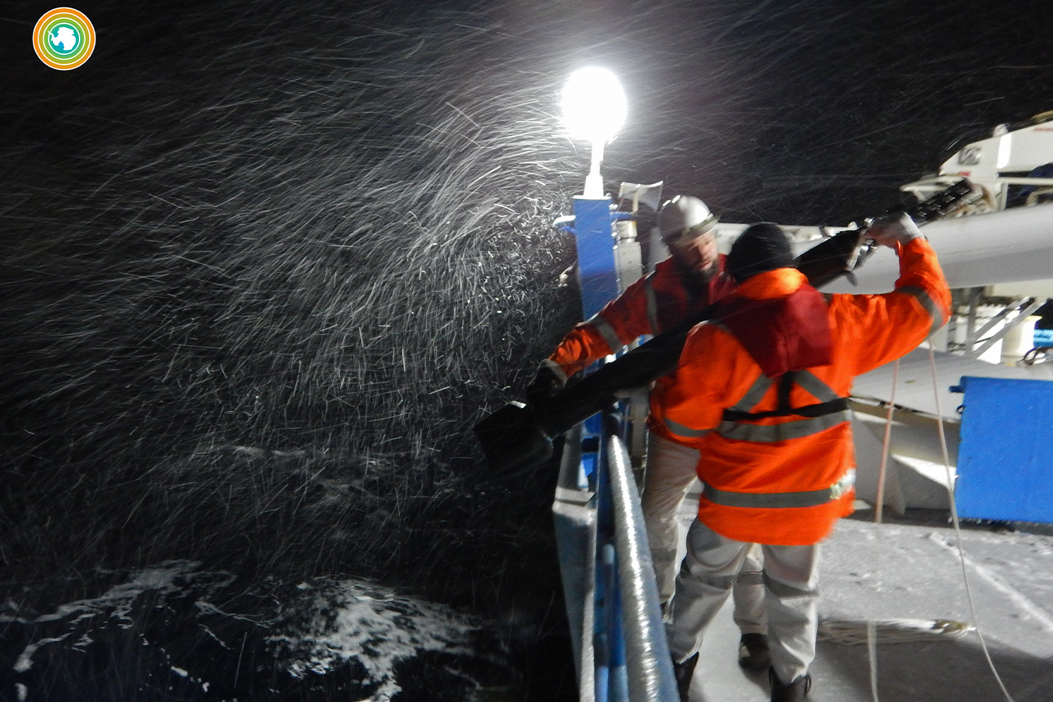 Launching a robot float in stormy weather. Robot floats in the Southern Ocean, where almost half of the global oceanic carbon sink occurs, can drift through rough seas in the worst weather at sub-zero temperatures, gathering data from places where research ships infrequently travel. Image by Melissa Miller/SOCCOM via Flickr (CC BY 2.0).
Better data, better models
Launching a robot float in stormy weather. Robot floats in the Southern Ocean, where almost half of the global oceanic carbon sink occurs, can drift through rough seas in the worst weather at sub-zero temperatures, gathering data from places where research ships infrequently travel. Image by Melissa Miller/SOCCOM via Flickr (CC BY 2.0).
Better data, better models
Fennel’s research group in Nova Scotia is keen to use all these new data streams as they become available to test ocean models and improve them. BGC-Argo floats in the Gulf of Mexico, for example, have already enabled one of her doctoral students to collect data from backscatter sensors to develop more realistic models of how organic matter travels downward in the ocean. This vertical flux of organic material plays a major role in sequestering ocean carbon. Past models that relied on satellite images of oceanic chlorophyll or flux estimates from sediment traps didn’t fit real-world events.
“We really need this supplemental information from the floats to get this right,” Fennel emphasizes. Her group is one of several Canadian research teams that is working with BGC-ARGO floats to improve modeling predictions.
Better models could also help evaluate ocean-based atmospheric carbon dioxide removal proposals like those recently reviewed by the U.S. National Academies of Science — schemes that range from injecting iron filings into the oceans to fertilize the growth of CO2-consuming phytoplankton, to sinking huge biomasses of kelp to the seafloor to help sequester more carbon.
“I think we have no hope of ever getting carbon dioxide removal [projects] off the ground without autonomous platforms like Argo floats,” Fennel says. They “can measure the parameters in a cost-effective way, in real time, at the right spatial and temporal resolution.”
Data and samples from robotic floats have already led to more than 200 published ocean biogeochemistry research papers over the past six years covering a range of topics, including the impact of typhoons on plankton, improving ocean oxygen budgets, identifying zones of oxygen depletion, and assessing the China Sea’s response to nutrient fluxes.
“The same way we ve been relying on measurements like [Charles] David Keeling s original Mauna Loa and South Pole measurements of [escalating] atmospheric carbon dioxide, with these robot floats we are now building [we will be able to develop] the measurements of record for the global ocean,” says Russell. And that could make all the difference in getting climate models right.
Banner image: A Royal Navy research vessel patrols Antarctica. The Southern Ocean around Antarctica accounts for almost half of the worldwide oceanic carbon sink. Image by Defence Imagery via Flickr (CC BY-NC-SA 2.0).
Citations:
Bushinsky, S. M., Landschützer, P., Rödenbeck, C., Gray, A. R., Baker, D., Mazloff, M. R., … Sarmiento, J. L. (2019). Reassessing Southern Ocean air-sea CO2 flux estimates with the addition of biogeochemical float observations. Global Biogeochemical Cycles, 33(11), 1370-1388. doi:10.1029/2019GB006176
Claustre, H., Johnson, K. S., Takeshita, Y. (2020). Observing the global ocean with Biogeochemical-Argo. Annual Review of Marine Science, 12(1), 23-48. doi:10.1146/annurev- marine- 010419- 010956
Gray, A. R., Johnson, K. S., Bushinsky, S. M., Riser, S. C., Russell, J. L., Talley, L. D., … Sarmiento, J. L. (2018). Autonomous biogeochemical floats detect significant carbon dioxide outgassing in the high-latitude Southern Ocean. Geophysical Research Letters, 45(17), 9049-9057. doi:10.1029/2018GL078013
Landschützer, P., Gruber, N., Haumann, F. A., Rödenbeck, C., Bakker, D. C., van Heuven, S., … Wanninkhof, R. (2015). The reinvigoration of the Southern Ocean carbon sink. Science, 349(6253), 1221-1224. doi:10.1126/science.aab2620
Le Quéré, C., Rödenbeck, C., Buitenhuis, E. T., Conway, T. J., Langenfelds, R., Gomez, A., … Heimann, M. (2007). Saturation of the Southern Ocean CO2 sink due to recent climate change. Science, 316(5832), 1735-1738. doi:10.1126/science.1136188
Williams, N. L., Feely, R. A., Sabine, C. L., Dickson, A. G., Swift, J. H., Talley, L. D., Russell, J. L. (2015). Quantifying anthropogenic carbon inventory changes in the Pacific sector of the Southern Ocean. Marine Chemistry, 174, 147-160. doi:10.1016/j.marchem.2015.06.015
FEEDBACK: Use this form to send a message to the author of this post. If you want to post a public comment, you can do that at the bottom of the page.