While wildfires are a natural part of California’s landscape, a severe drought, coupled with extreme temperatures and low rainfall, have sustained several major fires for much of August. The map shows wildfire hotspots along the US West Coast in 2021. Further north, a number of Canadian Provinces (including British Columbia) have also been experiencing intense fires since the end of June. The data has been extracted from NASA’s Fire Information for Resource Management System (FIRMS) which uses data from NASA's Moderate Resolution Imaging Spectroradiometer (MODIS) aboard the Terra and Aqua satellites and NASA's Visible Infrared Imaging Radiometer Suite (VIIRS) aboard the joint NASA/NOAA Suomi National Polar orbiting Partnership (Suomi NPP) and NOAA-20 satellites. Credit: ESA (Data: NASA FIRMS)
While wildfires are a natural part of California's landscape, a severe drought, coupled with extreme temperatures, have sustained several major fires for much of August. As of 14 September, more than 7,000 wildfires have been recorded, burning over 900,000 hectares across the state.
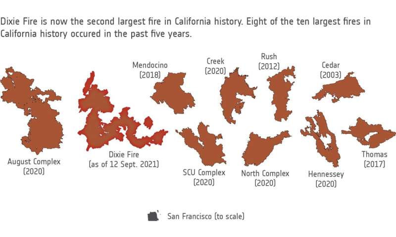
The Dixie megablaze, the largest wildfire of the 2021 fire season and the second-largest blaze in recorded state history, has burned more than 388,000 hectares of mainly forested land and has destroyed more than 1,200 buildings on its path. The fire, named after the road where is started, began on 13 July in the Feather River Canyon, and as of 14 September, is only 75% contained.
With thousands of firefighters continuing to battle the blaze, several were diverted to help harness the nearby Caldor Fire which has burned more than 88,700 hectares, threatening communities near Lake Tahoe before crossing the state's border over to Nevada.
The map above shows wildfire hotspots along the US West Coast in 2021. Further north, a number of Canadian Provinces, including British Columbia, have also been experiencing intense fires since the end of June.
The Copernicus Sentinel-2 mission has been used to image the fires. The Sentinel-2 satellites each carry just one instrument—a high-resolution multispectral imager with 13 spectral bands. Captured on 1 September, the smoke and burn scars of the Caldor and Dixie Fires are visible in this image.
While wildfires are a natural part of California’s landscape, a severe drought, coupled with extreme temperatures, have sustained several major fires for much of August. As of 14 September, more than 7000 wildfires have been recorded, burning over 900 000 hectares across the state. Credit: contains modified Copernicus Sentinel data (2021), processed by ESA, CC BY-SA 3.0 IGO
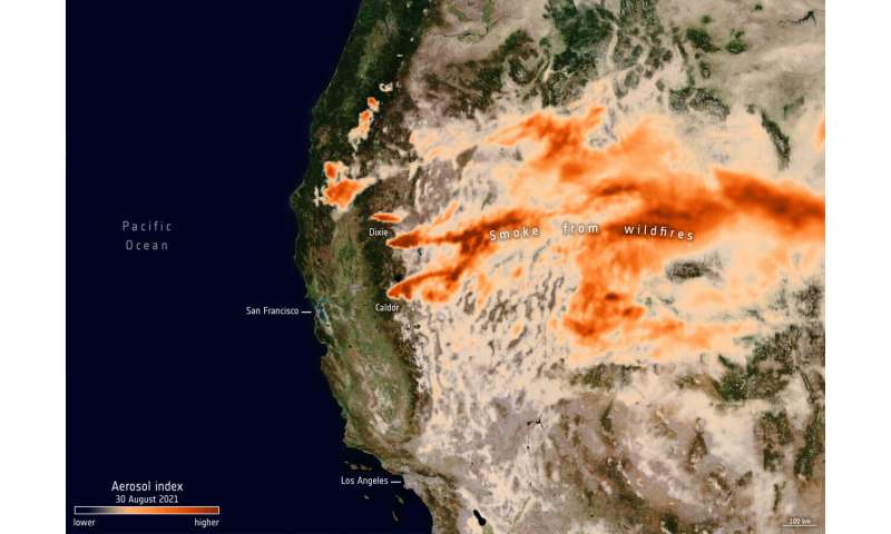
According to the Copernicus Atmosphere Monitoring Service (CAMS), smoke from the fires in North America has been transported across the continent and out over the Atlantic Ocean towards Europe yet is unlikely to affect Europeans as it is high up in the atmosphere. The smoke has, however, impacted air quality across the US and Canada, where it was much closer to the surface.
The Copernicus Sentinel-5P satellite is dedicated to monitoring air pollution by measuring a multitude of trace gases that affect the air we breathe. Images captured on 30 August show the presence of aerosols in the atmosphere caused by the fires. The plumes continued their journey eastwards, across the US even reaching Europe.
Claus Zehner, ESA's Copernicus Sentinel-5P mission manager, says, "Copernicus satellites like Sentinel-2, Sentinel-3 and Sentinel-5P allow on one hand the point source detection of fires, and on the other hand, to monitor the movement of the emitted air pollutants over different states in the US and even to another continent like Europe."
The Dixie megablaze, the largest wildfire of the 2021 fire season and the second-largest blaze in recorded state history, has burned more than 388 000 hectares of mainly forested land and has destroyed more than 1200 buildings on its path. The fire, named after the road where is started, began on 13 July in the Feather River Canyon, and as of 14 September, is only 75% contained. Credit: ESA (Data: CAL FIRE)
The Copernicus Sentinel-5P satellite captured the presence of aerosols caused by the ongoing wildfires in California on 30 August. The plumes of particles have been swept eastwards caused by western winds, even reaching Europe. Credit: contains modified Copernicus Sentinel data (2021), processed by ESA, CC BY-SA 3.0 IGO
As the fires continue to burn, hot and dry conditions and forecasted thunderstorms have prompted officials to issue warnings through part of the state's northwest coast.
Climate change is considered a key driver of this trend. In a recent report from the Intergovernmental Panel on Climate Change (IPCC), scientists concluded that that there is an unequivocal link between human activity and global warming. The report pointed to observations showing increases in drought and fires in the western United States, expecting this trend to continue in the future.
Citation:
California continues to burn (2021, September 16)
retrieved 16 September 2021
from https://phys.org/news/2021-09-california.html
This document is subject to copyright. Apart from any fair dealing for the purpose of private study or research, no
part may be reproduced without the written permission. The content is provided for information purposes only.


 have also been experiencing intense fires since the end of June. The data has been extracted from NASA’s Fire Information for Resource Management System (FIRMS) which uses data from NASA's Moderate Resolution Imaging Spectroradiometer (MODIS) aboard the Terra and Aqua satellites and NASA's Visible Infrared Imaging Radiometer Suite (VIIRS) aboard the joint NASA/NOAA Suomi National Polar orbiting Partnership (Suomi NPP) and NOAA-20 satellites. Credit: ESA (Data: NASA FIRMS)")
, processed by ESA, CC BY-SA 3.0 IGO")