|
Saban spoke of an older guide who had been arranging treks in the area for decades.
“This guide, he said before the 1980s there was a lot of ice here and people used to go there for ice training before climbing Everest.
“But now there’s no ice anymore.”
The Himalayas
The Himalayan mountain range cuts across the top of Nepal. The range itself is about 2,400 km in length and spans the countries of India, Pakistan, Afghanistan, China, Bhutan and Nepal.
The area is known as the “Third Pole” because of the large amount of glaciers there. The glaciers themselves are a vital source of water for 250 million people in the mountains as well as for 1.65 billion people in the areas below and are the source of 10 of the world’s important river systems.
As temperatures rise across the world as a result of human made climate change, the Himalayan glaciers are melting at an increased pace. A recent major report by the International Centre for Integrated Mountain Development (ICIMOD) in Nepal found that since the 1970s the glaciers have thinned and retreated.
The Hindu Kush Himalaya Assessment found that if global greenhouse gas emissions continue unabated, two-thirds of the glaciers could melt by the end of the century.
Even if global temperature increases are kept to 1.5 degrees Celsius (the ambitious goal of the 2015 Paris Agreement), the assessment found that one-third of the glaciers would be lost.
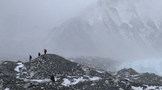 Everest Base Camp which is located on a glacier
This would dramatically change the livelihoods of billions of people who rely on the glaciers for food, water, energy and clean air. More immediately, the melting glaciers are causing glacial lakes to expand increasing the risk that they will burst and flood downstream.
“When we were kids in winter seasons – especially in December, January, February – it snowed a lot,” said Dawa Sherpa, a businessman and owner of the highest Irish Pub in the world at Namche Bazaar.
Dawa grew up in Namche and has noticed significant changes to the weather and landscape since he was a child.
“Now it hardly snows twice in the winter. That is [an indication] and the glaciers are melting, the lakes are getting bigger, [Lake] Imja is already in danger, so the signs are all there.”
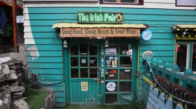 The highest Irish pub in the world at Namche Bazaar
Glacial lakes in Nepal
The Himalayan glaciers are giant structures of ice and packed snow that dominate the mountainous landscape. As they grow they accumulate debris – like rocks and stones – at the edges.
When temperatures increase and the glacier melts and recedes the rocks and debris become the natural dam (moraine) at the edge of the newly formed glacial lake. The lake grows from the melting glacier and risks bursting the moraine and causing a GLOF event.
The bursting of Dig Tsho in 1985 sparked a flurry of research into glacial lakes and the dangers posed by GLOFs and how to prevent them. Using satellite data, researchers found that certain lakes were growing at an alarming rate and posed significant risks.
“We use remote sensing to map and monitor glacier and glacial lakes. To see how glacial lakes have been increasing over the decades. Using this data we are able to publish the changes [across decades],” said Finu Shrestha, a research associate with ICIMOD mapping glaciers and the expansion of glacial lakes.
By using the same data we can see and have an accurate analysis of the glacier and [how it has] changed. In that time glacial lakes attached to glaciers have shown large expansions in the size.”
There are over 1,500 glacial lakes in Nepal. Research by ICIMOD has found 21 glacial lakes to be potentially dangerous and six to be in critical need of attention.
Imja Lake
After you leave the bustling town of Namche at 3,440m – where trekkers can pick up their last supplies and stay in relative comfort – you make your way through the small village of Tengboche with its Tibetan Buddhist Monastery, through the old Sherpa village of Pangboche and onto the tiny village of Dingboche at 4,410m altitude.
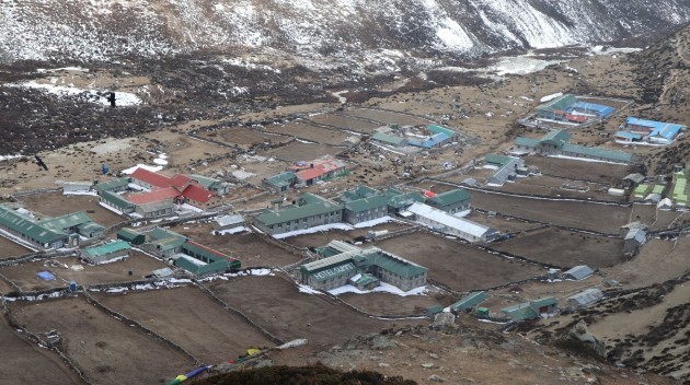 The village of Dingboche
The only way through these villages is by foot. All goods are carried up by porters or yaks and the land is mostly barren in the winter.
At Dingboche, most trekkers veer off north west on the way to Everest Base Camp, but continuing north east you make your way to the tiny collection of lodges that make up the village of Chukhung. A few more hours heading east and you’ll reach Imja Lake.
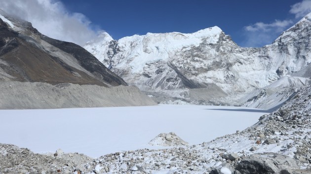
In February the lake was entirely frozen over, its surface unbroken and pure white stretching towards the foot of the shrinking Imja glacier which feeds it. At just over 5,000m the air is thin and the temperature in February drops to -15 C or below at night. The hills and mountains span off in every direction, uninhabited and covered in snow.
Imja lake – which is about 2km in length with a maximum depth of 90m – didn’t exist 60 years ago. Since then, it has grown as the glacier feeding it has receded. The lake is one of the most dangerous of Nepal’s glacial lakes and poses risks to Chukhung, Dingboche and even Namche Bazaar downstream.
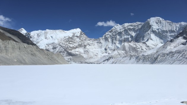 Imja Lake as grown hugely in the last 60 years
The work by ICIMOD categorises glacial lakes by how dangerous they are and presents reports which governments can then act upon. Because of its size and rapid pace of expansion, Imja is a Category 1 – or one the most dangerous lakes.
Following the devastation of the 2015 earthquake, the Nepalese Department of Hydrology and Meteorology, along with the United Nations Development Project, undertook an operation to drain the lake to make it safe.
After six months of work at a difficult altitude, an outlet was constructed and close to 4 million cubic metres of water was drained from the lake, with water levels lowering by 3.4 metres.
 Imja was drained but modelling suggests more needs to be done to ensure it is fully safe
An early warning monitoring system was also installed, which should warn ahead of time if the lake expands to dangerous levels.
The operation was carried out in order to prevent a GLOF event, with officials stating at the time that the process would be repeated with other dangerous lakes.
However, modelling studies have suggested that the lake must be lowered by at least 10m to prevent major damage and by 20m to completely eliminate the chance of a downstream GLOF.
In the years since the operation the lake has continued to grow, but researchers believe the risk has been mitigated for the time being.
“It will fill again but if the flow is contained I don’t think it will be a problem unless and until an avalanche into the lake itself happens,” said Finu Shrestha.
For Shrestha, other lakes are now in need of attention in order to avert potential disasters down the line. GLOF events are usually small events, some that occur in isolated areas with no communities nearby even go unnoticed.
But as the 1985 bursting of Dig Tsho shows they can be potentially catastrophic.
Living with the risk
For the people living and working in the area around the growing glacial lakes, the dangers seem present but at the same time far away.
#Open journalism
No news is bad news
Support The Journal
Your contributions will help us continue
to deliver the stories that are important to you
| 


