


Ice sheets blanket continents, obscuring nooks, crannies, and even mountains below. The lay of the land underneath ice sheets is not just a side note—the topography is crucially important to how the overlying ice might behave.
For years, researchers have been reconstructing the topography under Antarctic ice, essentially “peering” through the ice sheets with technology like ice-penetrating radar surveys.
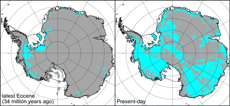
A team of scientists wanted to better understand how the topography changed under these continental-sized glaciers, so they worked backward, reconstructing the under-ice topography of Antarctica over the past 34 million years.
They found that over time, Antarctic topography has become progressively lower. The researchers noted that their reconstructions can provide important boundary conditions for modelers who are trying to estimate ice volumes and sea levels during past climatic changes.
Topography Matters
The ice sheets of Antarctica are big players in global sea level rise. Researchers are interested in how the East Antarctic and West Antarctic Ice Sheets behaved in the past, and they rely on modeling to reconstruct ice flows.
“Bed topography is a really important boundary condition in ice sheet models,” said Guy Paxman, a geophysicist at Durham University in the United Kingdom and lead author of the new study, published in Palaeogeography, Palaeoclimatology, Palaeoecology.
“If researchers are modeling ice sheets in deep geological time, they need to have a more realistic version of the topography than just using the present-day topography,” he added.
Two big factors control how ice sheets behave: the extent of land below sea level and the slope of the bed. Both characteristics can contribute to seawater seeping under the ice, a situation that encourages the glacier to start floating, become unstable, and break up. As ice sheets become unstable, they can retreat and contribute to sea level rise.
Contemporary topographic maps show that most of the bed in West Antarctica is below sea level and slopes inland. Because of that, West Antarctic glaciers such as Thwaites are of particular interest to researchers, said Dustin Schroeder, a radio glaciologist at Stanford University who was not involved with the study.
“One of the reasons we’re studying Thwaites Glacier is because of its shape,” said Schroeder, who added that like the Antarctic ice sheets themselves, the massive glacier could have been a big contributor to sea level rise in the past.
Bedrock Changes over Time
To better understand paleotopographic evolution in Antarctica, the team looked at four time slices in which significant climatic changes were preserved in the geologic record: 34 million years ago (when ice started to accumulate), 23 million years ago, 14 million years ago, and 3.5 million years ago.
Paxman said their study is the first attempt to reconstruct Antarctic topography for multiple time periods beginning when ice first started to accumulate. To do that, the team had to piece together an immense amount of data on erosion, volcanism, and land subsidence from both crustal rifting and the weight of the overlying ice.
To reconstruct erosion over the past 34 million years, the team examined sediment accumulation around the continent. Offshore seismic data helped them reconstruct how much land was lost through erosion, and deep-sea drilling cores helped build a more complete picture of the rate of sediment accumulation.
The team found that glacial erosion rates in East Antarctica appeared to be higher during the Oligocene, the first 10–15 million years of Antarctic glaciation. Paxman noted that erosion started to slow down after the middle Miocene (about 14 million years ago).
“This is the opposite situation [than] in West Antarctica, where erosion has picked up since the mid-Miocene,” he said.
In addition to erosion rates, the team looked at ice loading and the effects of rifting in West Antarctica, including thermal subsidence. Overall, the researchers determined that Antarctica’s topography has gotten progressively lower over time: 34 million years ago, there was about 25% more land above sea level than there is today.
“The most significant changes we tend to find are in the [West] Antarctic rift system,” said Paxman, but he added that there were also large changes in East Antarctica, especially in basins around margins of the continent.
Paleotopography in Practice
The new research shows that West Antarctica has changed a lot over time. “This paper said [that] in the past, the shape [of West Antarctica] was different—and really different,” said Schroeder. “That is where it is provocative and interesting.”
“When we do long-timescale modeling studies on these different topographies, I’m looking forward to seeing if that gives us insights into how things changed in the past,” said Schroeder. He added that this work might give additional insights into how uplift and erosion could affect glaciology and ice vulnerability. “I think it really gives us a tool to ask some important questions that were much harder to ask before.”
The team hopes that researchers will find the work useful for future studies. “These topographies are freely available to download,” said Paxman. “We’re really encouraging people [to download them.] If they want to model ice sheets in the past, these topographies are there as a boundary condition for whoever wants to look at some of these questions about past Antarctic ice sheets.”
—Sarah Derouin (@Sarah_Derouin), Freelance Journalist